

Select a municipality, town, or city above to learn more about that specific region.
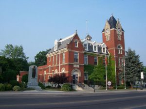
Elgin County and the City of St. Thomas are located in southwestern Ontario on the north shore of Lake Erie, bordered by Middlesex County to the north, the Municipality of Chatham-Kent to the West, Norfolk County to the east, and Oxford County to the northeast. Elgin County is an upper-tier municipality that is comprised of seven lower-tier municipalities: the Municipality of Bayham, Malahide Township, the Town of Aylmer, the Municipality of Central Elgin, Southwold Township, the Municipality of Dutton-Dunwich, and the Municipality of West Elgin. The City of St. Thomas is also located within Elgin County, but is considered a single-tier municipality with separate administration.
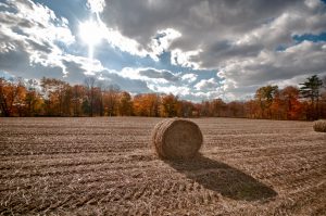
Elgin County is a largely rural area. Major industries in the Elgin County census division (including St. Thomas) include manufacturing, health care and social assistance, retail trade, and construction, employing 17%, 13%, 10%, and 10% of the workforce, respectively (2021). In comparison to Ontario as a whole, a larger proportion of Elgin County’s workforce is employed in both manufacturing and construction. Additionally, a larger proportion of Elgin County’s workforce is employed in the agriculture sector: 5% in Elgin County compared to 2% in Ontario (2021).
Major employers in Elgin County include the Integrated Grain Processing Co-Operative, Ontario Plants Propagation Limited, Steelway Building Systems, ETBO Tool and Die, and North Star Windows and Doors (source: Elgin County). Major manufacturing employers in St. Thomas include Masco Canada Limited and Formet Industries and Presstran Industries (both divisions of Magna Structural Systems Inc.) (Source: St. Thomas and District Chamber of Commerce)
Elgin County is situated on the traditional lands of the Attiwonderonk (Neutral), Haudenosaunee, and Anishinaabek, and later became home to the Lūnaapéewak Nations, on lands covered by the Upper Canada Treaties, specifically Treaty 2 (McKee Treaty, 1790) and Treaty 3 (Between the Lakes Purchase and Collins Purchase, 1792). This area is also covered by the Dish with One Spoon wampum, under which multiple nations came together in peace to care for the land and the resources of the Great Lakes. Today, Elgin County is also bordered by the communities of Munsee-Delaware First Nation, Chippewas of the Thames First Nation, and Oneida Nation of the Thames.
Elgin County Census Division
Population: 94 752
Area: 1878 km2
Largest population centre: St. Thomas
Number & percentage of immigrants: 10 920 (11.5% of the total population)
Number & percentage of new immigrants*: 835 (0.8% of the total population)
*Immigrated in the last five years (2016-2021)
Number & percentage of visible minorities: 4275 (4.5% of the total population)
Most common ethnic or cultural origins: Canadian, English, Irish, Scottish, German, Dutch, French, Mennonite
| English | 27 645 |
| Scottish | 19 750 |
| Canadian | 18 575 |
| Irish | 17 250 |
| German | 13 460 |
| Dutch | 9 165 |
| French | 6 910 |
| Mennonite | 4 395 |
Most common knowledge of language other than English: German, French, Plautdietsch, Spanish and Dutch
| German | 4305 |
| French | 3900 |
| Plautdietsch | 2870 |
| Low German* | 370 |
| Spanish | 1530 |
| Dutch | 885 |
*Low German is not in the top four, but is used interchangeably to refer to Plautdietsch, and so has been included to give a full picture of Plautdietsch speakers. It is also likely that some people reporting German language knowledge are referring to Plautdietsch.
Educational attainment:
| Highest certificate, diploma or degree* | Count | Percentage of population aged 25-64 years (25% sample data) |
| No certificate, diploma, or degree | 16 070 | 21% |
| Secondary school diploma or equivalency | 24 085 | 32% |
| Apprenticeship or trades certificate or diploma | 4860 | 6% |
| College, CEGEP or other non-university certificate or diploma | 20 375 | 27% |
| University certificate or diploma below bachelor level | 1000 | 1% |
| Bachelor’s degree or higher | 10 010 | 13% |
*For population aged 25-64 years, 25% sample data
Industries employing the largest percentage of the workforce: Manufacturing, Health Care and Social Assistance, Retail Trade, Construction, and Educational Services.
| Industry | Total | Male | Female |
| Manufacturing | 7995 | 5745 | 2250 |
| Health Care and Social Assistance | 6190 | 825 | 5370 |
| Retail Trade | 4745 | 2335 | 2415 |
| Construction | 4695 | 4150 | 550 |
| Educational Services | 2935 | 755 | 2180 |
The Municipality of Bayham

The Municipality of Bayham is the easternmost municipality in Elgin County. The largest population centre is Port Burwell.
Population: 7096
Area: 244 km2
Largest population centre: Port Burwell
Number & percentage of immigrants: 1300 (18% of total population)
Number & percentage of new immigrants*: 75 (1%)
*Immigrated in the last five years (2016-2021)
Number & percentage of visible minorities: 145 (2%)
Most common ethnic or cultural origins: Mennonite, Canadian, Mexican, English, German
Malahide Township

Malahide Township is situated between the Municipality of Central Elgin to the west and the Municipality of Bayham to the east and surrounds the Town of Aylmer. The largest population centre is Springfield.
Population: 9308
Area: 394 km2
Largest population centre: Springfield
Number & percentage of immigrants: 1495 (16% of total population)
Number & percentage of new immigrants*: 105 (1% of total population)
*Immigrated in the last five years (2016-2021)
Number & percentage of visible minorities: 155 (2% of total population)
Most common ethnic or cultural origins: English, Canadian, German, Mennonite, Scottish
The Town of Aylmer
The Town of Aylmer is surrounded by Malahide Township.
Population: 7699
Area: 6 km2
Largest population centre: N/A
Number & percentage of immigrants: 1295 (17% of total population)
Number & percentage of new immigrants*: 75 (1% of total population)
*Immigrated in the last five years (2016-2021)
Number & percentage of visible minorities: 240 (3% of total population)
Most common ethnic or cultural origins: German, English, Canadian, Scottish, Mennonite
The Municipality of Central Elgin

Central Elgin is located in the centre of Elgin County, bordered by Southwold Township to the west and Malahide Township to the east. The largest population centre is Port Stanley.
Population: 13 746
Area: 280 km2
Largest population centre: Port Stanley
Number & percentage of immigrants: 1340 (10% of total population)
Number & percentage of new immigrants*: 120 (1% of total population)
*Immigrated in the last five years (2016-2021)
Number & percentage of visible minorities: 420 (3% of total population)
Most common ethnic or cultural origins: English, Scottish, Irish, Canadian, German
The City of St. Thomas
The City of St. Thomas is surrounded by Central Elgin to the east and Southwold Township to the west.
Population: 42 840
Area: 36 km2
Largest population centre: N/A
Number & percentage of immigrants: 4400 (10% of total population)
Number & percentage of new immigrants*: 405 (1% of total population)
*Immigrated in the last five years (2016-2021)
Number & percentage of visible minorities: 2990 (7% of total population)
Most common ethnic or cultural origins: English, Scottish, Canadian, Irish, German
Southwold Township

Southwold Township is situated between the Municipality of Dutton-Dunwich to the west and the Municipality of Central Elgin to the east. The largest population centre is Shedden.
Population: 4851
Area: 301 km2
Largest population centre: Shedden
Number & percentage of immigrants: 310 (6% of total population)
Number & percentage of new immigrants*: 25 (0.5% of total population)
*Immigrated in the last five years (2016-2021)
Number & percentage of visible minorities: 105 (2% of total population)
Most common ethnic or cultural origins: English, Scottish, Canadian, Irish, Dutch
Municipality of Dutton-Dunwich

The Municipality of Dutton-Dunwich is located between the Municipality of West Elgin to the west and Southwold Township to the east. The largest population centre is Dutton.
Population: 4152
Area: 294 km2
Largest population centre: Dutton
Number & percentage of immigrants: 230 (6% of total population)
Number & percentage of new immigrants*: 15 (0.4% of total population)
*Immigrated in the last five years (2016-2021)
Number & percentage of visible minorities: 80 (2% of total population)
Most common ethnic or cultural origins: English, Scottish, Irish, Canadian, German
Municipality of West Elgin
The Municipality of West Elgin is the westernmost municipality in Elgin County. The largest population centre is West Lorne.
Population: 5060
Area: 322 km2
Largest population centre: West Lorne
Number & percentage of immigrants: 545 (11% of total population)
Number & percentage of new immigrants*: 20 (0.4% of total population)
*Immigrated in the last five years (2016-2021)
Number & percentage of visible minorities: 140 (3% of total population)
Most common ethnic or cultural origins: English, Scottish, Irish, Canadian, German
